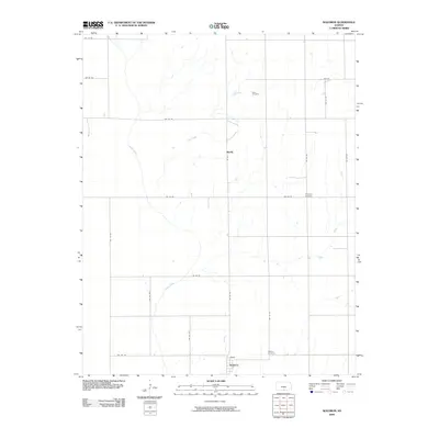
2009 Map of Waldron
USGS Topo · Published 2009About this map
Waldron sits at the southern edge of this Kansas landscape, defined by a rigid grid of agricultural roads and the meandering courses of Sandy Creek and Plum Creek. The settlement pattern is sparse, with small clusters like Ruella and Shook marking the rural intersections of Harper County. For those tracing family histories, three burial grounds are prominent across the quadrangle: Goss Cemetery to the north, Ferguson Cemetery in the center, and Waldron Cemetery just east of its namesake town. The Krider railroad line cuts through the southern portion of the map, signifying the importance of rail transport in moving goods from these prairie outposts. This 2009 survey reflects a landscape that has maintained its pastoral character, where the intersection of section lines like SW 60 RD and SW 80 Ave dictate the local geography.
Find a feature on this map
25 named features on this map. Tap any name to fly to it.
Don’t see what you’re looking for? This feature index may not catch every label — zoom into the map to look around manually.
Map Details
Editions of this 2009 Waldron Map
This is the sole edition of this map. No revisions or reprints were ever made.
Other maps of this area

1889 · Anthony
USGS Topo · 1:125,000

1891 · Anthony
USGS Topo · 1:125,000

1955 · Woodward
USGS Topo · 1:250,000

1955 · Pratt
USGS Topo · 1:250,000

1958 · Woodward
USGS Topo · 1:250,000

1959 · Pratt
USGS Topo · 1:250,000

1969 · Amorita
USGS Topo · 1:24,000
1969 · Manchester
USGS Topo · 1:24,000
1969 · Manchester NW
USGS Topo · 1:24,000

1972 · Attica
USGS Topo · 1:24,000