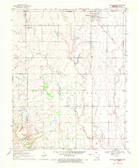
1969 Map of Manchester
USGS Topo · Published 1971About this map
The borderlands of Grant County, Oklahoma, and Harper County, Kansas, are defined by the intersection of agricultural grid lines and the meandering paths of Sand Creek and Cooper Creek. In the northeast corner, the town of Manchester sits alongside the Atchison Topeka and Santa Fe railroad, serving as a transit point for the region’s grain and cattle economy. The landscape is marked by the presence of local burial grounds and religious landmarks, including the IOOF Cem and the SS Peter and Paul church with its associated SS Peter and Paul Cem. These sites, along with several scattered Gravel Pits, highlight the local community's infrastructure and resource extraction during the late 1960s. The map captures the transition between the rolling prairie and the structured township boundaries of Parsons, Manchester, and Sand Creek.
Find a feature on this map
14 named features on this map. Tap any name to fly to it.
Don’t see what you’re looking for? This feature index may not catch every label — zoom into the map to look around manually.
Map Details
Editions of this 1969 Manchester Map
2 editions found
Other maps of this area

1889 · Anthony
USGS Topo · 1:125,000

1889 · Caldwell
USGS Topo · 1:125,000

1891 · Anthony
USGS Topo · 1:125,000

1893 · Caldwell
USGS Topo · 1:125,000

1897 · Caldwell
USGS Topo · 1:125,000

1955 · Wichita
USGS Topo · 1:250,000

1955 · Enid
USGS Topo · 1:250,000

1955 · Woodward
USGS Topo · 1:250,000

1955 · Pratt
USGS Topo · 1:250,000

1958 · Enid
USGS Topo · 1:250,000