1969 Map of Manchester
USGS Topo · Published 1982About this map
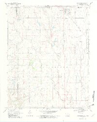
Manchester sits at the northern edge of Grant County, Oklahoma, just below the Kansas border in a landscape defined by agricultural section lines and petroleum development. The town is a critical junction for the Atchison Topeka and Santa Fe railroad, which cuts diagonally across the northeastern corner of the map. This era of the late 1960s highlights the importance of energy production in the region, centered on the Manchester Gas Field which spans the central portion of the survey.
Find a feature on this map
13 named features on this map. Tap any name to fly to it.
Don’t see what you’re looking for? This feature index may not catch every label — zoom into the map to look around manually.
Map Details
Editions of this 1969 Manchester Map
2 editions found
Other maps of this area

1889 · Anthony
USGS Topo · 1:125,000

1889 · Caldwell
USGS Topo · 1:125,000

1891 · Anthony
USGS Topo · 1:125,000

1893 · Caldwell
USGS Topo · 1:125,000
1897 · Caldwell
USGS Topo · 1:125,000

1955 · Wichita
USGS Topo · 1:250,000

1955 · Enid
USGS Topo · 1:250,000

1955 · Woodward
USGS Topo · 1:250,000

1955 · Pratt
USGS Topo · 1:250,000

1958 · Enid
USGS Topo · 1:250,000