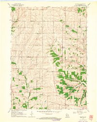
1962 Map of Waldwick
USGS Topo · Published 1964About this map
Waldwick and Fayette serve as the primary hubs in this early 1960s portrait of the driftless region, where the terrain is defined by the winding paths of Otter Creek, Canon Creek, and the Steiner Branch. The landscape reflects a deeply rooted rural society, with the Iowa Co Lafayette Co boundary bisecting a network of family-scale farmsteads and local institutions. Significant for genealogists and local historians, the sheet preserves the locations of several country schools and houses of worship, including Jackson Sch, Broad View Sch, and Bethel Ch.
Find a feature on this map
22 named features on this map. Tap any name to fly to it.
Don’t see what you’re looking for? This feature index may not catch every label — zoom into the map to look around manually.
Map Details
Editions of this 1962 Waldwick Map
2 editions found
Other maps of this area

1902 · Mineral Point
USGS Topo · 1:125,000

1923 · Blanchardville
USGS Topo · 1:62,500

1923 · South Wayne
USGS Topo · 1:62,500

1952 · Calamine
USGS Topo · 1:24,000

1952 · Mineral Point
USGS Topo · 1:24,000

1952 · Dodgeville
USGS Topo · 1:24,000

1954 · Rockford
USGS Topo · 1:250,000

1955 · Rockford
USGS Topo · 1:250,000

1958 · Rockford
USGS Topo · 1:250,000

1959 · Dubuque
USGS Topo · 1:250,000