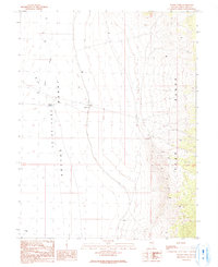
1990 Map of Waldy Pond
USGS Topo · Published 1991About this map
Jakes Depression Valley occupies the western portion of this landscape, characterized by the seasonal waters of Illipah Creek and the localized catchment at Waldy Pond. This 1990 provisional survey by the U.S. Geological Survey captures a remote section of White Pine County where the valley floor meets the rising slopes of the Egan Range. Human activity is sparse, marked primarily by utilitarian water management features like a Ditch and a Cistern, alongside a single Gravel Pit located near the center of the quadrangle. The eastern edge of the map is defined by the steep, intricately contoured foothills of the mountains, while several 4WD trails provide the only established routes through this high-altitude basin, serving as a record of land use before more recent developments in the region.
Find a feature on this map
10 named features on this map. Tap any name to fly to it.
Don’t see what you’re looking for? This feature index may not catch every label — zoom into the map to look around manually.
Map Details
Editions of this 1990 Waldy Pond Map
This is the sole edition of this map. No revisions or reprints were ever made.
Other maps of this area

1949 · Treasure Hill
USGS Topo · 1:62,500

1950 · Treasure Hill
USGS Topo · 1:62,500

1951 · Illipah
USGS Topo · 1:62,500

1956 · Ely
USGS Topo · 1:250,000

1958 · Reipetown
USGS Topo · 1:24,000

1958 · Giroux Wash
USGS Topo · 1:24,000

1959 · Ely
USGS Topo · 1:250,000

1959 · Reipetown
USGS Topo · 1:62,500

1959 · Preston Reservoir
USGS Topo · 1:62,500

1963 · Ely
USGS Topo · 1:250,000