
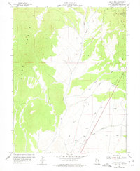
1958 Map of Giroux Wash
USGS Topo · Published 1961About this map
The Egan Range dominates the western half of this 1950s survey, overlooking a complex network of arid drainages that define the high desert topography of White Pine County. Central to the landscape is Giroux Wash, where seasonal water courses like White River Wash and Spring Wash converge in a wide valley. Human activity in this mid-century period is marked by infrastructure supporting regional communication and transport, including a Radio Relay Sta atop Rib Hill and a remote Landing Strip near Holt Creek. The map documents a period when industrial and agricultural access relied on the Headhouse Road and numerous Jeep Trails cutting through the sagebrush. These features, alongside isolated labels like Gravel Pit and several Dry Wells, illustrate the challenges of resource extraction and water management in this interior Nevada basin.
Find a feature on this map
22 named features on this map. Tap any name to fly to it.
Don’t see what you’re looking for? This feature index may not catch every label — zoom into the map to look around manually.
Map Details
Editions of this 1958 Giroux Wash Map
2 editions found
Other maps of this area

1952 · Ely
USGS Topo · 1:125,000

1956 · Ely
USGS Topo · 1:250,000

1958 · Ruth
USGS Topo · 1:24,000

1958 · Ely
USGS Topo · 1:62,500

1958 · McGill
USGS Topo · 1:62,500

1958 · Reipetown
USGS Topo · 1:24,000

1958 · Ely
USGS Topo · 1:24,000

1959 · Ely
USGS Topo · 1:250,000

1959 · Reipetown
USGS Topo · 1:62,500

1959 · Preston Reservoir
USGS Topo · 1:62,500