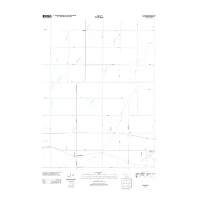
2013 Map of Wales
USGS Topo · Published 2013About this map
The unincorporated settlements of Wales and McPherson anchor this 2013 survey of Montgomery County. The landscape is defined by a grid-like network of rural avenues, including Boxelder Ave and Evergreen Ave, which facilitate movement between these quiet agricultural communities. A distinct southeast-to-northwest drainage pattern is evident through several watercourses, most notably Walnut Cr and Crabapple Cr, which carve gentle paths through the farmland. In the southern reaches, the small community of Hawthorne sits near the crossing of Walnut Cr, while the Red Oak Municipal Airport occupies the southeastern corner. This map offers a clear view of the rural infrastructure and land use in Iowa at the start of the 2010s, showcasing the persistent layout of section-line roads and the relationship between local creeks and small hamlets.
Find a feature on this map
32 named features on this map. Tap any name to fly to it.
Don’t see what you’re looking for? This feature index may not catch every label — zoom into the map to look around manually.
Map Details
Editions of this 2013 Wales Map
This is the sole edition of this map. No revisions or reprints were ever made.
Other maps of this area

1954 · Omaha
USGS Topo · 1:250,000

1955 · Nebraska City
USGS Topo · 1:250,000

1957 · Nebraska City
USGS Topo · 1:250,000

1957 · Omaha
USGS Topo · 1:250,000

1958 · Omaha
USGS Topo · 1:250,000

1958 · Nebraska City
USGS Topo · 1:250,000

1978 · Carson
USGS Topo · 1:24,000

1978 · Griswold
USGS Topo · 1:24,000
1978 · Emerson
USGS Topo · 1:24,000

1978 · Wales
USGS Topo · 1:24,000