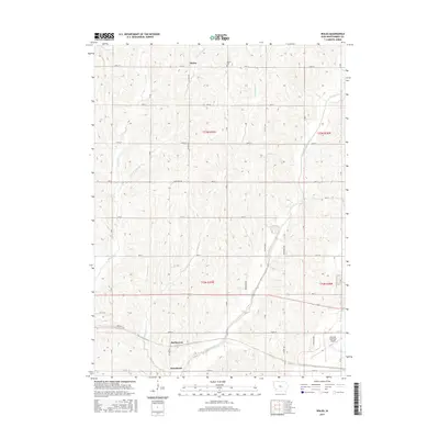
2015 Map of Wales
USGS Topo · Published 2015About this map
Wales stands as a primary settlement in this section of Montgomery County, where the agricultural landscape of Iowa is intricately carved by several watercourses. The drainage patterns of Walnut Creek and Crabapple Cr define the terrain, which is organized by a strict grid of section roads including Boxelder Ave and 130th St. In the northern reaches, the Gomer Cem provides a point of genealogical interest near the small community of Wales. The southern portion of the map transition into the vicinity of Hawthorne and McPherson, where the geography becomes more industrialized near the Red Oak Municipal Airport. This area illustrates the persistence of small rural hubs alongside modern regional infrastructure, showing how local transport routes like 200th St connect these legacy townships to larger transportation centers.
Find a feature on this map
28 named features on this map. Tap any name to fly to it.
Don’t see what you’re looking for? This feature index may not catch every label — zoom into the map to look around manually.
Map Details
Editions of this 2015 Wales Map
This is the sole edition of this map. No revisions or reprints were ever made.
Other maps of this area

1954 · Omaha
USGS Topo · 1:250,000

1955 · Nebraska City
USGS Topo · 1:250,000

1957 · Nebraska City
USGS Topo · 1:250,000

1957 · Omaha
USGS Topo · 1:250,000

1958 · Omaha
USGS Topo · 1:250,000

1958 · Nebraska City
USGS Topo · 1:250,000

1978 · Carson
USGS Topo · 1:24,000

1978 · Griswold
USGS Topo · 1:24,000
1978 · Emerson
USGS Topo · 1:24,000

1978 · Wales
USGS Topo · 1:24,000