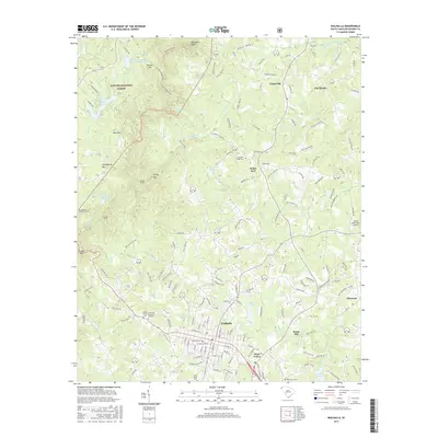
2017 Map of Walhalla
USGS Topo · Published 2017About this map
Walhalla serves as the focal point of this Oconee County landscape, where the foothills topography transitions into the steep slopes of the Blue Ridge. The town's historical geography is defined by a series of cemeteries including Westview Cem and Lutheran Cem, reflecting the area's long-established communities. North of the town center, the terrain is marked by significant engineering features of the nineteenth-century rail era, including the Stumphouse Mountain Tunnel, Middle Tunnel, and Saddle Tunnel, which were part of an ambitious but ultimately incomplete attempt to connect the coast to the Ohio River valley. The surrounding Sumter National Forest preserves much of the watershed for the Walhalla Reservoir and Cane Creek, while peripheral settlements like West Union and Ebenezer maintain distinct identities along the primary travel corridors. These physical markers, alongside landmarks like Burns Mill and the Hawks Nest Farm Airport, provide a detailed view of how industry and transportation routes shaped this mountain-edge region.
Find a feature on this map
156 named features on this map. Tap any name to fly to it.
Don’t see what you’re looking for? This feature index may not catch every label — zoom into the map to look around manually.
Map Details
Editions of this 2017 Walhalla Map
This is the sole edition of this map. No revisions or reprints were ever made.
Other maps of this area

1886 · Walhalla
USGS Topo · 1:125,000

1888 · Pickens
USGS Topo · 1:125,000

1892 · Walhalla
USGS Topo · 1:125,000

1894 · Pickens
USGS Topo · 1:125,000

1896 · Walhalla
USGS Topo · 1:125,000

1954 · Greenville
USGS Topo · 1:250,000

1958 · Greenville
USGS Topo · 1:250,000

1958 · Seneca
USGS Topo · 1:24,000

1959 · Salem
USGS Topo · 1:24,000
1959 · Walhalla
USGS Topo · 1:24,000