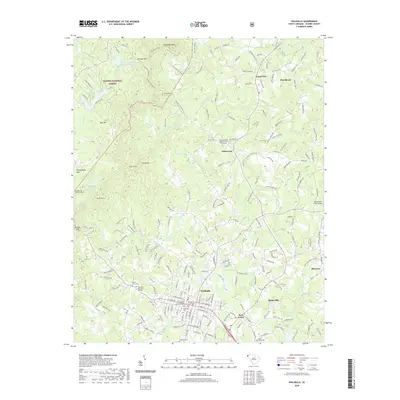
2020 Map of Walhalla
USGS Topo · Published 2020About this map
Walhalla serves as the focal point of this Oconee County landscape, where the street grid of W Main St and E Main St anchors the community near the Oconee County Courthouse. The town is surrounded by a complex network of cemeteries, including Westview Cem, Evergreen Memorial Gardens, and the Rocky Knoll Cem. To the north, the terrain rises sharply into the Sumter National Forest, characterized by landmarks such as Tamassee Knob and Stumphouse Mtn. A significant engineering relic, the Stumphouse Mountain Tunnel, remains a notable feature near the Walhalla Reservoir. The map illustrates the transition from the dense settlement of West Union to the more dispersed rural areas like Picket Post and Ebenezer, with Burns Mill reflecting the historical industrial presence along the local waterways such as Cane Cr and Coneross Cr.
Find a feature on this map
49 named features on this map. Tap any name to fly to it.
Don’t see what you’re looking for? This feature index may not catch every label — zoom into the map to look around manually.
Map Details
Editions of this 2020 Walhalla Map
This is the sole edition of this map. No revisions or reprints were ever made.
Other maps of this area

1886 · Walhalla
USGS Topo · 1:125,000

1888 · Pickens
USGS Topo · 1:125,000

1892 · Walhalla
USGS Topo · 1:125,000

1894 · Pickens
USGS Topo · 1:125,000

1896 · Walhalla
USGS Topo · 1:125,000

1954 · Greenville
USGS Topo · 1:250,000

1958 · Greenville
USGS Topo · 1:250,000

1958 · Seneca
USGS Topo · 1:24,000

1959 · Salem
USGS Topo · 1:24,000
1959 · Walhalla
USGS Topo · 1:24,000