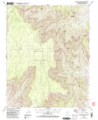
1988 Map of Walhalla Plateau
USGS Topo · Published 1988About this map
Walhalla Plateau dominates this high-elevation landscape, where the flat upland abruptly gives way to the intricate erosional features of Grand Canyon National Park. The topography here transition from the forested heights near Greenland Lake down into a complex network of side canyons like Natchi Canyon and the Kwagunt Valley. Human presence is evidenced by archaeological Ruins and the Walhalla Glades, suggesting a long history of occupation in these sheltered reaches before the area was preserved. Notable landmarks include the Hartman Natural Bridge and several towering geological formations named for mythological and historical figures, such as Juno Temple, Thor Temple, and Jupiter Temple. Natural water sources, including Cliff Spring and Cheyava Falls, were vital for the various groups who navigated this vertical terrain, which also shows evidence of modern utility through a Gravel Pit and numerous designated viewpoints like Vista Encantada.
Find a feature on this map
43 named features on this map. Tap any name to fly to it.
Don’t see what you’re looking for? This feature index may not catch every label — zoom into the map to look around manually.
Map Details
Editions of this 1988 Walhalla Plateau Map
2 editions found
Other maps of this area

1886 · Echo Cliffs
USGS Topo · 1:250,000

1886 · Kaibab
USGS Topo · 1:250,000

1891 · Echo Cliffs
USGS Topo · 1:250,000

1903 · Bright Angel
USGS Topo · 1:48,000

1906 · Bright Angel
USGS Topo · 1:48,000

1907 · Vishnu
USGS Topo · 1:48,000

1953 · Grand Canyon
USGS Topo · 1:250,000

1954 · Nankoweap
USGS Topo · 1:62,500

1956 · Marble Canyon
USGS Topo · 1:250,000

1957 · Grand Canyon
USGS Topo · 1:250,000