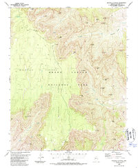
1988 Map of Walhalla Plateau
USGS Topo · Published 1988About this map
The Walhalla Plateau and its surrounding geological formations define this 1980s landscape within Grand Canyon National Park. This portion of the North Rim reveals a high-elevation environment where Greenland Lake sits near the head of drainage systems that carve deep into the canyon floor. Dramatic promontories such as Cape Final and Vista Encantada overlook a complex network of canyons, including Natchi Canyon, while prominent formations like Thor Temple, Jupiter Temple, and Juno Temple rise as isolated buttes. Evidence of earlier inhabitants is preserved in the form of Ruins found along the glades. The intricate hydrology of the area is represented by Cheyava Falls and several springs, which feed into major watercourses like Clear Creek, Lava Creek, and Unkar Creek as they descend toward the inner gorge.
Find a feature on this map
42 named features on this map. Tap any name to fly to it.
Don’t see what you’re looking for? This feature index may not catch every label — zoom into the map to look around manually.
Map Details
Editions of this 1988 Walhalla Plateau Map
2 editions found
Other maps of this area

1886 · Echo Cliffs
USGS Topo · 1:250,000

1886 · Kaibab
USGS Topo · 1:250,000

1891 · Echo Cliffs
USGS Topo · 1:250,000

1903 · Bright Angel
USGS Topo · 1:48,000

1906 · Bright Angel
USGS Topo · 1:48,000

1907 · Vishnu
USGS Topo · 1:48,000

1953 · Grand Canyon
USGS Topo · 1:250,000

1954 · Nankoweap
USGS Topo · 1:62,500

1956 · Marble Canyon
USGS Topo · 1:250,000

1957 · Grand Canyon
USGS Topo · 1:250,000