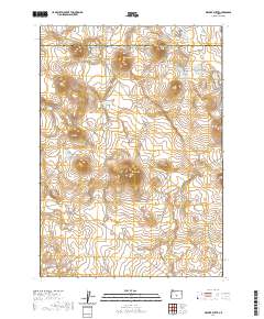
2020 Map of Walker Butte
USGS Topo · Published 2020About this map
Walker Butte and its surrounding volcanic landscape dominate this high-desert region of Central Oregon, situated along the county line shared by Deschutes and Lake Counties. The terrain is defined by prominent elevations including North Butte, South Butte, and Stevens Butte, which rise sharply above the expansive Squaw Flat. Water sources in this arid environment are sparse and localized, marked by small catchments and springs such as Basalt Lake, Button Springs, and the East Reservoir. Navigation across this segment of the high desert relies on historical corridors like Millican Rd and Fox Butte Rd, which cut through the drainage systems of China Hollow and provide access to remote livestock waterholes like the North Butte Waterhole.
Find a feature on this map
14 named features on this map. Tap any name to fly to it.
Don’t see what you’re looking for? This feature index may not catch every label — zoom into the map to look around manually.
Map Details
Editions of this 2020 Walker Butte Map
This is the sole edition of this map. No revisions or reprints were ever made.
Other maps of this area

1955 · Crescent
USGS Topo · 1:250,000

1957 · Crescent
USGS Topo · 1:250,000

1958 · Crescent
USGS Topo · 1:250,000

1970 · Crescent
USGS Topo · 1:250,000

1981 · Fox Butte
USGS Topo · 1:24,000

1981 · Hogback Butte
USGS Topo · 1:24,000
1981 · Plot Butte
USGS Topo · 1:24,000

1982 · Peters Creek Sink
USGS Topo · 1:24,000

1982 · Jacks Place
USGS Topo · 1:24,000
1983 · Soldiers Cap
USGS Topo · 1:24,000