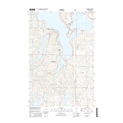
2016 Map of Walker
USGS Topo · Published 2016About this map
Walker sits along the southwestern shores of Walker Bay, serving as a central hub within the sprawling Chippewa National Forest. This 2016 survey illustrates the intricate relationship between land and water in north-central Minnesota, where Leech Lake dominates the eastern half of the map. Across Agency Narrows, the settlement of Onigum occupies the tip of a prominent peninsula, while Ah-gwah-ching is situated further south along the shoreline. The topography is defined by glacial kettle lakes and wetlands, including Lake May, Little Bass Lake, and the cluster of Upper Fifth Lake and Fifth Lake. For those tracking the region's heritage, the map identifies several distinct burial sites such as Evergreen Cem, Saint Agnes Cem, and the Medicine Rite Cem. Outdoor recreation and historical routes are marked by the N Country National Scenic Trail as it winds through the timbered landscape near the Shingobee River.
Find a feature on this map
73 named features on this map. Tap any name to fly to it.
Don’t see what you’re looking for? This feature index may not catch every label — zoom into the map to look around manually.
Map Details
Editions of this 2016 Walker Map
This is the sole edition of this map. No revisions or reprints were ever made.
Other maps of this area

1953 · Brainerd
USGS Topo · 1:250,000

1954 · Bemidji
USGS Topo · 1:250,000

1957 · Brainerd
USGS Topo · 1:250,000

1957 · Bemidji
USGS Topo · 1:250,000

1958 · Bemidji
USGS Topo · 1:250,000

1958 · Brainerd
USGS Topo · 1:250,000

1965 · Brainerd
USGS Topo · 1:250,000

1970 · Hackensack
USGS Topo · 1:24,000

1970 · Webb Lake
USGS Topo · 1:24,000
1970 · Crystal Lake
USGS Topo · 1:24,000