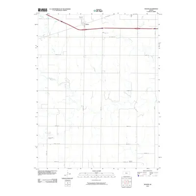
2010 Map of Walker
USGS Topo · Published 2010About this map
Walker serves as the primary settlement hub on this High Plains landscape, situated along the northern corridor where modern transit routes parallel the historic Old Hwy 40. The terrain is defined by a dense network of watercourses, most notably the meandering paths of Big Creek, the North Fork Big Creek, and Mud Creek. This area of Ellis County preserves its heritage through several dispersed burial grounds, including the Saint Anna Cemetery near the northern boundary and Saint Boniface Cemetery further south. The map reveals a highly structured rural grid, with family-named or descriptive roads like Walker Ave, Vincent Ave, and Grants Villa Rd connecting the agricultural plots and small creeks. The drainage patterns of Walker Creek in the east demonstrate the local geography's role in shaping the placement of section roads and farmsteads.
Find a feature on this map
30 named features on this map. Tap any name to fly to it.
Don’t see what you’re looking for? This feature index may not catch every label — zoom into the map to look around manually.
Map Details
Editions of this 2010 Walker Map
This is the sole edition of this map. No revisions or reprints were ever made.
Other maps of this area

1896 · Russell
USGS Topo · 1:125,000

1896 · Hays
USGS Topo · 1:125,000

1955 · Great Bend
USGS Topo · 1:250,000

1957 · Great Bend
USGS Topo · 1:250,000

1958 · Great Bend
USGS Topo · 1:250,000

1961 · Catharine
USGS Topo · 1:24,000
1961 · Walker
USGS Topo · 1:24,000

1961 · Russell SW
USGS Topo · 1:24,000

1961 · Victoria
USGS Topo · 1:24,000

1967 · Russell NW
USGS Topo · 1:24,000