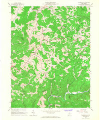
1966 Map of Walkersville
USGS Topo · Published 1968About this map
The West Fork River winds through the northern portion of this landscape, marking the northern reaches of Collins Settlement in the mid-1960s. The community of Walkersville serves as a local hub near the Baltimore and Ohio rail line, which follows the river's path through the narrow valleys. A significant historical marker is the Fort Pickens Monument near Duffy, signaling the area's importance during the Civil War era.
Find a feature on this map
75 named features on this map. Tap any name to fly to it.
Don’t see what you’re looking for? This feature index may not catch every label — zoom into the map to look around manually.
Map Details
Editions of this 1966 Walkersville Map
2 editions found
Other maps of this area

1893 · Buckhannon
USGS Topo · 1:125,000

1893 · Sutton
USGS Topo · 1:125,000

1896 · Buckhannon
USGS Topo · 1:125,000

1897 · Buckhannon
USGS Topo · 1:125,000

1906 · Burnsville
USGS Topo · 1:62,500

1908 · Sutton
USGS Topo · 1:48,000

1910 · Sutton Special
USGS Topo · 1:62,500

1912 · Crawford
USGS Topo · 1:48,000

1913 · Hacker Valley
USGS Topo · 1:48,000

1914 · Crawford
USGS Topo · 1:62,500