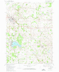
1972 Map of Walkerton
USGS Topo · Published 1974About this map
Walkerton serves as a significant rail junction in this northern Indiana landscape, where the Baltimore and Ohio, Penn Central, and Norfolk and Western lines intersect. The map illustrates a region transitioning from concentrated small-town centers to a network of rural roads and water features like Yellow Bank Creek and Hardys Lake. To the south, the community of Koontz Lake straddles the county line, showing a dense settlement pattern around the water's edge. Local education and religious life are anchored by Glenn High Sch and Township Sch, while rural pockets like Teegarden and Tyner highlight the persistent small-town structure of the early 1970s. Industrial activity is visible in several Gravel Pits, pointing to the local extraction economy that supported the area's development.
Find a feature on this map
32 named features on this map. Tap any name to fly to it.
Don’t see what you’re looking for? This feature index may not catch every label — zoom into the map to look around manually.
Map Details
Editions of this 1972 Walkerton Map
This is the sole edition of this map. No revisions or reprints were ever made.
Other maps of this area

1953 · Chicago
USGS Topo · 1:250,000

1957 · Chicago
USGS Topo · 1:250,000

1957 · Knox East
USGS Topo · 1:24,000

1957 · Plymouth
USGS Topo · 1:24,000

1958 · Donaldson
USGS Topo · 1:24,000

1958 · La Paz
USGS Topo · 1:24,000

1958 · Hamlet
USGS Topo · 1:24,000

1958 · Walkerton
USGS Topo · 1:24,000

1958 · Stillwell
USGS Topo · 1:24,000

1958 · North Liberty
USGS Topo · 1:24,000