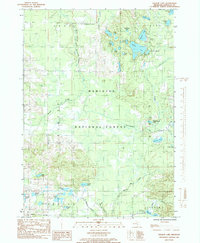
1985 Map of Walkup Lake
USGS Topo · Published 1985About this map
The Big South Branch Pere Marquette River carves through the central portion of this mid-1980s terrain, defining a landscape dominated by the protected acreage of the Manistee National Forest. This region of Newaygo County is characterized by a dense concentration of glacial kettle lakes and wetlands, ranging from the prominent Walkup Lake and Nichols Lake in the northeast to the smaller clusters of Triple Lakes and Lake of the Woods. Civil development is concentrated at Walgamor Corners, while the remainder of the map reveals a network of forest roads and creeks like Bear Creek and Heald Creek. The presence of a Gravel Pit near the western boundary indicates the local extractive industry that supported the maintenance of this remote road system. For those interested in the hydrology of Michigan's lower peninsula, the map provides a clear picture of the drainage patterns feeding into the Pere Marquette watershed via Winnepesaug Creek and Beaver Creek.
Find a feature on this map
43 named features on this map. Tap any name to fly to it.
Don’t see what you’re looking for? This feature index may not catch every label — zoom into the map to look around manually.
Map Details
Editions of this 1985 Walkup Lake Map
This is the sole edition of this map. No revisions or reprints were ever made.
Other maps of this area

1931 · Walkerville NE
USGS Topo · 1:31,680

1931 · Custer SE
USGS Topo · 1:31,680

1931 · Walkerville SE
USGS Topo · 1:31,680

1954 · Milwaukee
USGS Topo · 1:250,000

1954 · Midland
USGS Topo · 1:250,000

1958 · Midland
USGS Topo · 1:250,000

1958 · Milwaukee
USGS Topo · 1:250,000

1958 · Hesperia
USGS Topo · 1:62,500

1959 · Midland
USGS Topo · 1:250,000

1959 · Baldwin
USGS Topo · 1:62,500