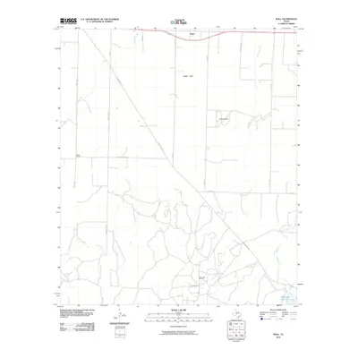
2010 Map of Wall
USGS Topo · Published 2010About this map
Wall serves as the primary community anchor in this 2010 topographic survey of Tom Green County. The landscape is defined by the broad, level expanse of Lipan Flat, where a geometric grid of local roads like Mikulik Rd, Susan Peak Rd, and Walling Pecan Rd delineates large agricultural tracts. The southern portion of the quadrangle reveals a more complex industrial and hydrologic character, featuring the Susan Peak Oil Field and the winding course of Dry Lipan Creek. Local history is preserved through landmarks like the Scherz School and family-named infrastructure, while the southeastern corner is marked by Lipan Creek and the Whitehead Reservoir. This map illustrates the intersection of Texas ranching heritage, petroleum extraction, and rural educational history in the early 21st century.
Find a feature on this map
20 named features on this map. Tap any name to fly to it.
Don’t see what you’re looking for? This feature index may not catch every label — zoom into the map to look around manually.
Map Details
Editions of this 2010 Wall Map
This is the sole edition of this map. No revisions or reprints were ever made.
Other maps of this area

1892 · San Angelo
USGS Topo · 1:125,000

1924 · San Angelo 2-c
USGS Topo · 1:48,000

1924 · San Angelo 2-b
USGS Topo · 1:48,000

1928 · Wall
USGS Topo · 1:62,500

1954 · San Angelo
USGS Topo · 1:250,000

1957 · Eola
USGS Topo · 1:62,500
1957 · San Angelo South
USGS Topo · 1:24,000

1957 · Wall
USGS Topo · 1:62,500

1958 · San Angelo
USGS Topo · 1:250,000

1965 · San Angelo
USGS Topo · 1:250,000