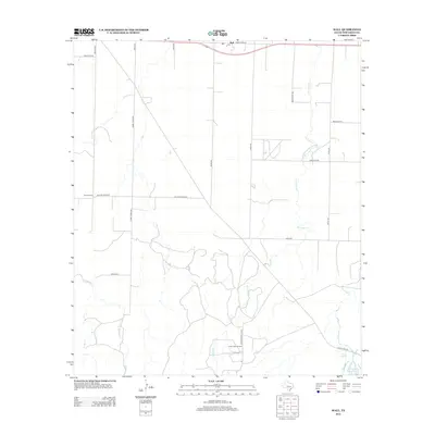
2012 Map of Wall
USGS Topo · Published 2012About this map
The small community of Wall sits in the northern reaches of this West Texas landscape, positioned along State Loop 570. This 2012 survey illustrates a transition from the agricultural grid to the industrial activity of the southern portion of the quadrangle. The presence of the Susan Peak Oil Field and the Marathon Oil Co Rd indicates the importance of energy extraction to the local economy. Water resources are scarce but vital, marked by the courses of Ninemile Cr and Dry Lipan Cr, which lead toward Lipan Spring and the Whitehead Reservoir in the southeast. For local historians, the location of the Scherz School on Walling Pecan Rd provides a specific point of interest regarding the area's social and educational history.
Find a feature on this map
24 named features on this map. Tap any name to fly to it.
Don’t see what you’re looking for? This feature index may not catch every label — zoom into the map to look around manually.
Map Details
Editions of this 2012 Wall Map
This is the sole edition of this map. No revisions or reprints were ever made.
Other maps of this area

1892 · San Angelo
USGS Topo · 1:125,000

1924 · San Angelo 2-c
USGS Topo · 1:48,000

1924 · San Angelo 2-b
USGS Topo · 1:48,000

1928 · Wall
USGS Topo · 1:62,500

1954 · San Angelo
USGS Topo · 1:250,000

1957 · Eola
USGS Topo · 1:62,500
1957 · San Angelo South
USGS Topo · 1:24,000

1957 · Wall
USGS Topo · 1:62,500

1958 · San Angelo
USGS Topo · 1:250,000

1965 · San Angelo
USGS Topo · 1:250,000