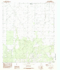
1984 Map of Wall
USGS Topo · Published 1984About this map
Lipan Flat defines the upper portion of this West Texas landscape, a broad and level expanse that contrasts with the more dissected terrain to the south. The small community of Wall sits near the northern boundary, serving as a focal point for the surrounding agricultural and ranching lands. Water drainage is dominated by the seasonal paths of Lipan Creek and Dry Lipan Creek, which wind through the southern hills and mesas toward the flatter plains.
Find a feature on this map
7 named features on this map. Tap any name to fly to it.
Don’t see what you’re looking for? This feature index may not catch every label — zoom into the map to look around manually.
Map Details
Editions of this 1984 Wall Map
This is the sole edition of this map. No revisions or reprints were ever made.
Other maps of this area

1892 · San Angelo
USGS Topo · 1:125,000

1924 · San Angelo 2-c
USGS Topo · 1:48,000

1924 · San Angelo 2-b
USGS Topo · 1:48,000

1928 · Wall
USGS Topo · 1:62,500

1954 · San Angelo
USGS Topo · 1:250,000

1957 · Eola
USGS Topo · 1:62,500
1957 · San Angelo South
USGS Topo · 1:24,000

1957 · Wall
USGS Topo · 1:62,500

1958 · San Angelo
USGS Topo · 1:250,000

1965 · San Angelo
USGS Topo · 1:250,000