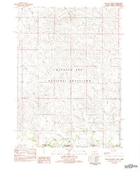
1982 Map of Wallace Ranch
USGS Topo · Published 1982About this map
Buffalo Gap National Grassland and Oglala National Grassland meet at the boundary between South Dakota and Nebraska, where the arid High Plains terrain is carved by an intricate network of intermittent watercourses. In the early 1980s, this landscape was defined by isolated homesteads like Wallace Ranch and Barkley Ranch, which sat along the southern drainage of Indian Creek. The map documents a complex hydrology of forks and gulches, including the North Fork, Middle Fork, and South Fork that feed into larger systems across the state line. This survey, compiled from mid-1970s aerial photography, captures the sparsely populated ranching country before modern development, detailing local landmarks such as Black Gulch, Alkali Creek, and Mid Fk Duck Creek. It reveals how human settlement in this border region followed the reliable path of the creek beds through the expansive grasslands.
Find a feature on this map
18 named features on this map. Tap any name to fly to it.
Don’t see what you’re looking for? This feature index may not catch every label — zoom into the map to look around manually.
Map Details
Editions of this 1982 Wallace Ranch Map
This is the sole edition of this map. No revisions or reprints were ever made.
Other maps of this area

1902 · Edgemont
USGS Topo · 1:125,000

1954 · Torrington
USGS Topo · 1:250,000

1955 · Hot Springs
USGS Topo · 1:250,000

1955 · Newcastle
USGS Topo · 1:250,000

1955 · Alliance
USGS Topo · 1:250,000

1957 · Alliance
USGS Topo · 1:250,000

1958 · Torrington
USGS Topo · 1:250,000

1958 · Alliance
USGS Topo · 1:250,000

1958 · Newcastle
USGS Topo · 1:250,000

1978 · Coffee Flats
USGS Topo · 1:24,000