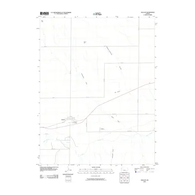
2009 Map of Wallace
USGS Topo · Published 2009About this map
Wallace sits along the southern edge of the high plains, positioned where the terrain breaks toward the Smoky Hill River valley. This 2009 survey highlights a landscape deeply connected to frontier military history and early settlement, most notably through the Fort Wallace Post Cemetery and the separate Wallace Cemetery. The town's grid, featuring 2nd St and 3rd St, remains the primary hub for a ranching and farming region defined by seasonal drainages like Depperschmidt Draw and Headquarters Draw. To the north, the elevation rises toward Motti Hill and the Red Hills, while water features such as Pond Creek and the Big Lagoon illustrate the precious nature of surface water in this arid portion of western Kansas. The map captures the intersection of traditional topography and the modern road network, including numerous rural routes like Wa N-28 and Wa E-T that link these isolated landmarks.
Find a feature on this map
29 named features on this map. Tap any name to fly to it.
Don’t see what you’re looking for? This feature index may not catch every label — zoom into the map to look around manually.
Map Details
Editions of this 2009 Wallace Map
This is the sole edition of this map. No revisions or reprints were ever made.
Other maps of this area

1954 · Goodland
USGS Topo · 1:250,000

1955 · Scott City
USGS Topo · 1:250,000

1956 · Goodland
USGS Topo · 1:250,000

1957 · Goodland
USGS Topo · 1:250,000

1958 · Scott City
USGS Topo · 1:250,000

1959 · Wallace
USGS Topo · 1:62,500

1959 · Harris Draw
USGS Topo · 1:62,500

1969 · Russell Springs 2 NW
USGS Topo · 1:24,000

1969 · Russell Springs 2 SW
USGS Topo · 1:24,000
1969 · Mc Allaster
USGS Topo · 1:24,000