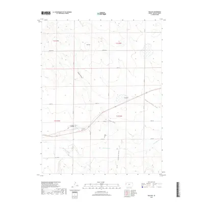
2018 Map of Wallace
USGS Topo · Published 2018About this map
Wallace stands as a central point in this High Plains landscape, situated just north of where the Smoky Hill River cuts through the western Kansas terrain. The map documents a territory defined by its drainage patterns, with numerous named draws such as Headquarters Draw, Depperschmidt Draw, and Capper Draw feeding toward the river valley. A significant historical site is preserved here in the form of the Fort Wallace Post Cem and the nearby Fort Wallace Cem, marking the legacy of the 19th-century frontier military post. The topography is further punctuated by Motti Hill to the north and the localized depression of Big Lagoon to the east. Modern land use is illustrated by a grid of rural routes, including Tumbleweed Rd and Quartz Rd, which navigate the elevation changes near Homestead Canyon.
Find a feature on this map
32 named features on this map. Tap any name to fly to it.
Don’t see what you’re looking for? This feature index may not catch every label — zoom into the map to look around manually.
Map Details
Editions of this 2018 Wallace Map
This is the sole edition of this map. No revisions or reprints were ever made.
Other maps of this area

1954 · Goodland
USGS Topo · 1:250,000

1955 · Scott City
USGS Topo · 1:250,000

1956 · Goodland
USGS Topo · 1:250,000

1957 · Goodland
USGS Topo · 1:250,000

1958 · Scott City
USGS Topo · 1:250,000

1959 · Wallace
USGS Topo · 1:62,500

1959 · Harris Draw
USGS Topo · 1:62,500

1969 · Russell Springs 2 NW
USGS Topo · 1:24,000

1969 · Russell Springs 2 SW
USGS Topo · 1:24,000
1969 · Mc Allaster
USGS Topo · 1:24,000