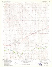
1979 Map of Wallace
USGS Topo · Published 1980About this map
Fort Wallace (Site) stands as a focal point for this western Kansas landscape, where the historical layer of frontier defense meets the late-twentieth-century topography. The map illustrates a complex network of dry draws and canyons, such as Depperschmidt Draw and Homestead Canyon, which feed into the valley of the Smoky Hill River. The presence of the Butterfield Overland Trail trace, running parallel to the Union Pacific railroad, highlights the enduring importance of this east-west transit corridor across the High Plains.
Find a feature on this map
20 named features on this map. Tap any name to fly to it.
Don’t see what you’re looking for? This feature index may not catch every label — zoom into the map to look around manually.
Map Details
Editions of this 1979 Wallace Map
This is the sole edition of this map. No revisions or reprints were ever made.
Other maps of this area

1954 · Goodland
USGS Topo · 1:250,000

1955 · Scott City
USGS Topo · 1:250,000

1956 · Goodland
USGS Topo · 1:250,000

1957 · Goodland
USGS Topo · 1:250,000

1958 · Scott City
USGS Topo · 1:250,000

1959 · Wallace
USGS Topo · 1:62,500

1959 · Harris Draw
USGS Topo · 1:62,500

1969 · Russell Springs 2 NW
USGS Topo · 1:24,000

1969 · Russell Springs 2 SW
USGS Topo · 1:24,000
1969 · Mc Allaster
USGS Topo · 1:24,000