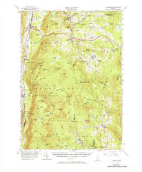
1955 Map of Wallingford
USGS Topo · Published 1969About this map
Otter Creek and the Vermont R R corridor anchor the western edge of this mid-century survey, where the village of Wallingford serves as a primary gateway to the Green Mountains. The landscape transitions from the valley floor to the high elevations of the Green Mountain National Forest, marked by peaks like Mount Tabor and Buckball Peak. A network of historic paths, including the famous Long Trail, traverses the ridge lines, connecting remote water bodies such as Little Rock Pond and Griffith Lake.
Find a feature on this map
112 named features on this map. Tap any name to fly to it.
Don’t see what you’re looking for? This feature index may not catch every label — zoom into the map to look around manually.
Map Details
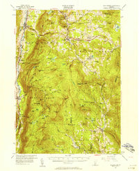
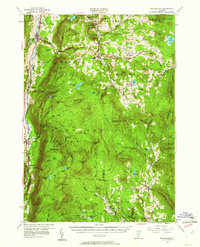
Editions of this 1955 Wallingford Map
3 editions found
Other maps of this area

1891 · Rutland
USGS Topo · 1:62,500

1893 · Wallingford
USGS Topo · 1:62,500

1893 · Rutland
USGS Topo · 1:62,500

1894 · Londonderry
USGS Topo · 1:62,500

1894 · Pawlet
USGS Topo · 1:62,500

1894 · Equinox
USGS Topo · 1:62,500

1895 · Castleton
USGS Topo · 1:62,500

1896 · Equinox
USGS Topo · 1:62,500

1897 · Pawlet
USGS Topo · 1:62,500

1897 · Castleton
USGS Topo · 1:62,500