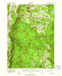
1955 Map of Wallingford
USGS Topo · Published 1961About this map
Otter Creek and the Rutland Railroad corridor define the western edge of this mid-century Vermont landscape, where the Green Mountains rise sharply into the Green Mountain National Forest. The map documents a transition between the valley industry of Wallingford and the high-elevation settlements like Belmont and Mount Holly. Significant local landmarks include the Weston Priory and the Wantagequet Trout Club, reflecting the area's spiritual and recreational history.
Find a feature on this map
89 named features on this map. Tap any name to fly to it.
Don’t see what you’re looking for? This feature index may not catch every label — zoom into the map to look around manually.
Map Details
Editions of this 1955 Wallingford Map
3 editions found

Other maps of this area

1891 · Rutland
USGS Topo · 1:62,500

1893 · Wallingford
USGS Topo · 1:62,500

1893 · Rutland
USGS Topo · 1:62,500

1894 · Londonderry
USGS Topo · 1:62,500

1894 · Pawlet
USGS Topo · 1:62,500

1894 · Equinox
USGS Topo · 1:62,500

1895 · Castleton
USGS Topo · 1:62,500

1896 · Equinox
USGS Topo · 1:62,500

1897 · Pawlet
USGS Topo · 1:62,500

1897 · Castleton
USGS Topo · 1:62,500