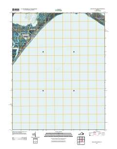
2011 Map of Wallops Island
USGS Topo · Published 2011About this map
The National Aeronautics and Space Administration Wallops Flight Facility dominates the coastal landscape of this 2011 survey, situated along the sensitive marshlands and barrier islands of Virginia's Eastern Shore. This area reflects a critical intersection of federal aerospace operations and the natural shifting geography of the mid-Atlantic coast. The map illustrates the specialized infrastructure required for maritime and space exploration, bordered by the tidal waters of Bogues Bay and the open Atlantic Ocean. To the north and east, the transition from Wallops Island toward Assateague Island is marked by Chincoteague Inlet and the sheltered Toms Cove, highlighting the dynamic barrier island system. The presence of Wallops Beach provides a reference for the ever-changing shoreline that defines this unique coastal research and launch corridor.
Find a feature on this map
8 named features on this map. Tap any name to fly to it.
Don’t see what you’re looking for? This feature index may not catch every label — zoom into the map to look around manually.
Map Details
Editions of this 2011 Wallops Island Map
This is the sole edition of this map. No revisions or reprints were ever made.
Other maps of this area

1931 · Accomac
USGS Topo · 1:48,000

1935 · Accomac
USGS Topo · 1:62,500

1942 · Chincoteague East
USGS Topo · 1:24,000

1942 · Mappsville
USGS Topo · 1:24,000

1942 · Wallops Island
USGS Topo · 1:24,000

1943 · Mappsville
USGS Topo · 1:31,680

1943 · Chincoteague West
USGS Topo · 1:31,680
1943 · Hallwood
USGS Topo · 1:31,680

1943 · Wallops Island
USGS Topo · 1:31,680
1943 · Chincoteague East
USGS Topo · 1:31,680