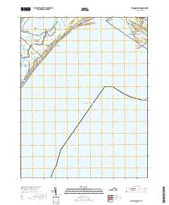
2019 Map of Wallops Island
USGS Topo · Published 2019About this map
Wallops Island and its adjacent coastal marshes define this section of the Accomack County shoreline. The landscape is a complex network of tidal waterways, including Bogues Bay and the narrow passage of Island Hole Narrows, which separate the barrier island from the Virginia mainland. To the north, the protected lands of the Chincoteague National Wildlife Refuge and Assateague Island National Seashore meet at Chincoteague Inlet, a primary opening to the Atlantic Ocean.
Find a feature on this map
17 named features on this map. Tap any name to fly to it.
Don’t see what you’re looking for? This feature index may not catch every label — zoom into the map to look around manually.
Map Details
Editions of this 2019 Wallops Island Map
This is the sole edition of this map. No revisions or reprints were ever made.
Other maps of this area

1931 · Accomac
USGS Topo · 1:48,000

1935 · Accomac
USGS Topo · 1:62,500

1942 · Chincoteague East
USGS Topo · 1:24,000

1942 · Mappsville
USGS Topo · 1:24,000

1942 · Wallops Island
USGS Topo · 1:24,000

1943 · Mappsville
USGS Topo · 1:31,680

1943 · Chincoteague West
USGS Topo · 1:31,680
1943 · Hallwood
USGS Topo · 1:31,680

1943 · Wallops Island
USGS Topo · 1:31,680
1943 · Chincoteague East
USGS Topo · 1:31,680