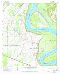
1963 Map of Walls
USGS Topo · Published 1971About this map
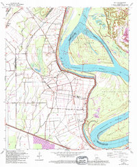
Profit Island dominates the bend of the Mississippi River as it winds through West Baton Rouge Parish, creating a complex landscape of chutes and oxbow lakes. The low-lying terrain is defined by a intricate network of waterways including The Chenal, Grand Bayou, and Bayou Tiger, which support the agricultural settlements of Smithfield and Chamberlin. The Texas and Pacific railroad line cuts a straight path across the alluvial plain, connecting small communities like Arbroth, Walls, and Bueche. Cultural life in this era is centered around numerous country churches, such as Zion Traveler Ch and St Pauls Ch, while the proximity to the river necessitates an extensive Levee system. This 1963 survey captures the area before modern industrial expansion, preserving the locations of the Devall Sch and a historic Indian Mound near Lake Clause.
Find a feature on this map
55 named features on this map. Tap any name to fly to it.
Don’t see what you’re looking for? This feature index may not catch every label — zoom into the map to look around manually.
Map Details
Editions of this 1963 Walls Map
5 editions found
Other maps of this area

1906 · Bayou Sara
USGS Topo · 1:125,000

1908 · Baton Rouge
USGS Topo · 1:62,500

1939 · Zachary
USGS Topo · 1:62,500

1939 · Baton Rouge
USGS Topo · 1:62,500

1940 · Grosse Tete
USGS Topo · 1:62,500

1953 · Baton Rouge West
USGS Topo · 1:24,000

1953 · Lobdell
USGS Topo · 1:24,000

1953 · New Roads
USGS Topo · 1:24,000

1954 · Zachary
USGS Topo · 1:24,000

1954 · Port Hudson
USGS Topo · 1:24,000