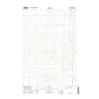
2017 Map of Wallum
USGS Topo · Published 2017About this map
Wallum serves as a small point of reference in this expansive section of Golden Valley County, where the landscape is defined by the winding paths of several drainage systems. The seasonally significant waters of Swimming Woman Cr and Careless Cr cut through the terrain, illustrating the ranching and agricultural foundations of the region. A network of rural routes, including Hedgesville Rd and Rothemay Rd, provide the primary infrastructure connecting isolated homesteads and sections. The presence of Alkali Cr further highlights the characteristic hydrology of central Montana's plains, where these creeks dictate the placement of local roads like Wallum Rd and Jessie Rd. This survey documents the persistent grid of townships and ranges that have organized this landscape for over a century.
Find a feature on this map
15 named features on this map. Tap any name to fly to it.
Don’t see what you’re looking for? This feature index may not catch every label — zoom into the map to look around manually.
Map Details
Editions of this 2017 Wallum Map
This is the sole edition of this map. No revisions or reprints were ever made.
Other maps of this area

1889 · Big Snowy Mountain
USGS Topo · 1:250,000

1893 · Big Snowy Mountain
USGS Topo · 1:250,000

1954 · Roundup
USGS Topo · 1:250,000

1958 · Roundup
USGS Topo · 1:250,000

1986 · Ryegate West
USGS Topo · 1:24,000
1986 · Ryegate East
USGS Topo · 1:24,000

1986 · Halbert Creek South
USGS Topo · 1:24,000
1986 · Deadmans Basin Reservoir
USGS Topo · 1:24,000

1986 · Halbert Creek North
USGS Topo · 1:24,000

1986 · Wallum
USGS Topo · 1:24,000