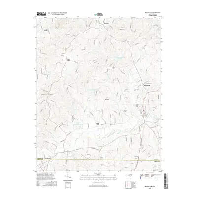
2016 Map of Walnut Cove
USGS Topo · Published 2016About this map
Walnut Cove serves as the central hub of this Stokes County landscape, situated at a bend in Town Fork Creek where the Norfolk Southern rail line passes through the settlement. To the southwest, the village of Germanton sits along the county line, while the northern terrain is defined by the elevation of Piney Mtn and the waters of the Dan River in the northeast corner. This modern survey reflects a region managed through local water resources, evidenced by several watershed reservoirs including Town Fork Cr Watershed Lake Fifteen and Town Fork Creek Watershed Lake Thirteen. Smaller rural communities like Brook Cove, Rosebud, and Baileytown are connected by a network of family-named roads such as Gene Martin Rd and Jimmie Bullins Rd, while the Fulp Cem provides a specific point of interest for those researching local lineage.
Find a feature on this map
165 named features on this map. Tap any name to fly to it.
Don’t see what you’re looking for? This feature index may not catch every label — zoom into the map to look around manually.
Map Details
Editions of this 2016 Walnut Cove Map
This is the sole edition of this map. No revisions or reprints were ever made.
Other maps of this area

1951 · Rural Hall
USGS Topo · 1:24,000

1951 · Walkertown
USGS Topo · 1:24,000

1953 · Winston-Salem
USGS Topo · 1:250,000

1955 · Winston-Salem
USGS Topo · 1:250,000

1962 · Winston-Salem
USGS Topo · 1:250,000

1964 · Hanging Rock
USGS Topo · 1:24,000

1964 · King
USGS Topo · 1:24,000

1969 · Belews Creek
USGS Topo · 1:24,000
1971 · Walnut Cove
USGS Topo · 1:24,000
1971 · Belews Lake
USGS Topo · 1:24,000