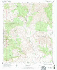
1969 Map of Walnut Grove
USGS Topo · Published 1978About this map
The Hassayampa River flows through this corner of the Prescott National Forest, shaping a landscape of ranching and mining history in Yavapai County. The small community of Walnut Grove serves as the focal point, where the Walnut Grove Sch and Walnut Grove Cem reflect the area's established roots. Evidence of the region's mineral wealth is scattered throughout the hills, specifically at the Silver Crown Mine and the historical Copper Camp (Site). Ranching life is well-documented through numerous family-named landmarks such as the T K Bar Ranch, Carter Ranch, and Whitehead Ranch. The presence of several windmills, including the French Gulch Windmill and Hodgkins Windmill, underscores the importance of water management in this arid terrain, where Pack Trails and Jeep Trails provide the primary means of navigating the high ground near Black Mountain.
Find a feature on this map
45 named features on this map. Tap any name to fly to it.
Don’t see what you’re looking for? This feature index may not catch every label — zoom into the map to look around manually.
Map Details
Editions of this 1969 Walnut Grove Map
2 editions found
Other maps of this area

1887 · Prescott
USGS Topo · 1:250,000

1892 · Prescott
USGS Topo · 1:250,000

1903 · Bradshaw Mountains
USGS Topo · 1:125,000

1903 · Congress
USGS Topo · 1:125,000

1904 · Congress
USGS Topo · 1:125,000

1947 · Crown King
USGS Topo · 1:62,500

1947 · Mt. Union
USGS Topo · 1:62,500

1947 · Kirkland
USGS Topo · 1:62,500

1947 · Wagoner
USGS Topo · 1:62,500

1948 · Crown King
USGS Topo · 1:63,360