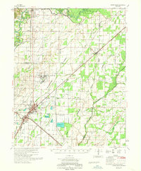
1968 Map of Walnut Ridge
USGS Topo · Published 1968About this map
The St Louis San Francisco and Missouri Pacific railroads define the transit corridor through this section of Northeast Arkansas, converging at the established regional hubs of Walnut Ridge and Hoxie. The landscape is heavily shaped by complex water management systems designed to drain the flat lowlands, evidenced by the extensive network of the Little Rock Memphis Flume, Tupelo Ditch, and Conley Ditch. These man-made channels cut across the terrain to manage the flow of the Black River and the Cache River.
Find a feature on this map
104 named features on this map. Tap any name to fly to it.
Don’t see what you’re looking for? This feature index may not catch every label — zoom into the map to look around manually.
Map Details
Editions of this 1968 Walnut Ridge Map
This is the sole edition of this map. No revisions or reprints were ever made.
Other maps of this area

1932 · Walnut Ridge
USGS Topo · 1:62,500

1934 · Powhatan
USGS Topo · 1:62,500

1935 · Powhatan
USGS Topo · 1:62,500

1935 · Sedgwick
USGS Topo · 1:62,500

1935 · Alicia
USGS Topo · 1:62,500

1935 · Knobel
USGS Topo · 1:62,500

1935 · Reyno
USGS Topo · 1:62,500

1935 · Walnut Ridge
USGS Topo · 1:62,500

1939 · Jonesboro
USGS Topo · 1:62,500

1940 · Gainesville
USGS Topo · 1:62,500