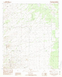
1982 Map of Walnut Wells NE
USGS Topo · Published 1982About this map
The Animas Mountains dominate this high-desert landscape in Hidalgo County, where a network of ephemeral drainages flows from the mountain slopes toward the eastern plains. These watercourses, including Darling Creek, Cottonwood Creek, and Millsite Creek, define the topography and movement of the region. A solitary Check Dam located between the hills suggests the critical importance of water management and erosion control in this arid environment during the late 1970s and early 1980s. The map illustrates a remote cattle-ranching landscape where place names like Cowboy Creek and Gillespie Creek reflect local geography and heritage. The absence of significant settlements or road infrastructure emphasizes the high-elevation isolation of the southwest corner of New Mexico during this period of geological survey.
Find a feature on this map
12 named features on this map. Tap any name to fly to it.
Don’t see what you’re looking for? This feature index may not catch every label — zoom into the map to look around manually.
Map Details
Editions of this 1982 Walnut Wells NE Map
This is the sole edition of this map. No revisions or reprints were ever made.
Other maps of this area

1918 · Big Hatchet Peak
USGS Topo · 1:62,500

1918 · Hachita
USGS Topo · 1:62,500

1918 · Walnut Wells
USGS Topo · 1:62,500

1918 · Playas
USGS Topo · 1:62,500

1919 · Playas
USGS Topo · 1:62,500

1923 · Walnut Wells
USGS Topo · 1:62,500

1955 · Douglas
USGS Topo · 1:250,000

1959 · Douglas
USGS Topo · 1:250,000

1961 · Douglas
USGS Topo · 1:250,000

1964 · Douglas
USGS Topo · 1:250,000