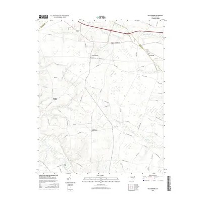
2016 Map of Walstonburg
USGS Topo · Published 2016About this map
Walstonburg and the surrounding coastal plain of Greene and Pitt Counties are defined by a complex network of wetlands and small agricultural communities. This landscape is dominated by extensive drainage systems including Little Contentnea Cr and numerous named pocosin-like features such as Thompson Swamp and Lighter Knot Swamp. The settlement pattern follows the higher ground between these wetlands, connecting established crossroads like Fieldsboro and Castoria. The eastern edge of the map shows the growth of Farmville near the Pitt County line, where Sunset Memorial Park is situated. Transportation is anchored by local routes such as Beaman Old Creek Rd and School House Rd, which trace the historical rural infrastructure of the region. Distinctive local landmarks like Fools Bridge over Contentnea Creek highlight the intersection of early river crossings and modern road networks in this agrarian territory.
Find a feature on this map
69 named features on this map. Tap any name to fly to it.
Don’t see what you’re looking for? This feature index may not catch every label — zoom into the map to look around manually.
Map Details
Editions of this 2016 Walstonburg Map
This is the sole edition of this map. No revisions or reprints were ever made.
Other maps of this area

1904 · Falkland
USGS Topo · 1:62,500

1904 · Wilson
USGS Topo · 1:62,500

1914 · Kinston
USGS Topo · 1:48,000

1916 · Kinston
USGS Topo · 1:62,500

1953 · Rocky Mount
USGS Topo · 1:250,000

1954 · Rocky Mount
USGS Topo · 1:250,000

1957 · Goldsboro
USGS Topo · 1:62,500
1978 · Stantonsburg
USGS Topo · 1:24,000
1978 · Saratoga
USGS Topo · 1:24,000

1980 · Falkland
USGS Topo · 1:24,000