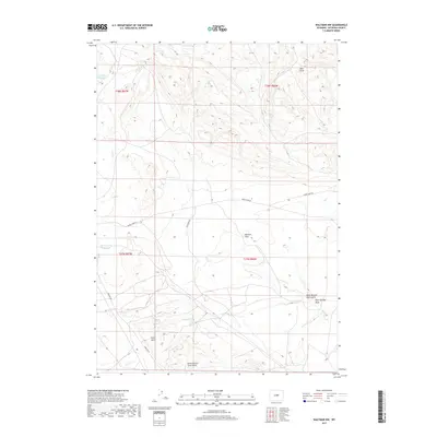
2017 Map of Waltman NW
USGS Topo · Published 2017About this map
Ralston Flats anchors this high-plains landscape, where the drainage patterns of several intermittent creeks and gulches reveal the complex hydrologic character of central Wyoming. Local transportation relies on historic corridors like Baker Cabin Rd and Arminto Rd, which cross the township lines of the t37n r86w and t38n r87w survey blocks. The presence of Jackpot Reservoir and the Bad Water Cr Reservoir indicates the critical importance of managed water collection in this arid environment, providing essential infrastructure for local land use. Water sources like Dean Springs and the flow of Poison Cr are vital landmarks in a terrain defined by deep erosional features such as Cave Gulch and Okie Draw. This 2017 survey details the topographical nuances and the network of unpaved routes, including Old Bump Rd, that sustain the region's ranching or industrial activities.
Find a feature on this map
18 named features on this map. Tap any name to fly to it.
Don’t see what you’re looking for? This feature index may not catch every label — zoom into the map to look around manually.
Map Details
Editions of this 2017 Waltman NW Map
This is the sole edition of this map. No revisions or reprints were ever made.
Other maps of this area

1952 · Deadman Butte
USGS Topo · 1:24,000

1952 · Arminto
USGS Topo · 1:24,000

1952 · Waltman NW
USGS Topo · 1:24,000

1952 · Waltman
USGS Topo · 1:24,000

1952 · Hiland
USGS Topo · 1:24,000

1952 · Badwater SE
USGS Topo · 1:24,000

1955 · Arminto
USGS Topo · 1:250,000

1958 · Arminto
USGS Topo · 1:250,000

1962 · Arminto
USGS Topo · 1:250,000
1968 · Notches Dome
USGS Topo · 1:24,000