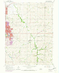
1964 Map of Walton
USGS Topo · Published 1973About this map
Lincoln expands eastward during this period, with the suburban growth of Bethany and Havelock meeting the rural sections of Lancaster County. The landscape is defined by the drainage of Stevens Creek and the operations of the Chicago Rock Island and Pacific railroad, which cuts through the northern bluffs. This 1960s survey, updated in the early 1970s, documents the transition from institutional and agricultural land, such as the University of Nebraska Experimental Farm, to residential developments. The area includes significant local landmarks like the V A Hospital, Seacrest Field, and Hillcrest Country Club. Local history and genealogy are anchored by features like the Fairview Cem and Schultz Cem, alongside various country schools like Meadow View Sch and School No 157 that still served the outskirts of the growing city.
Find a feature on this map
52 named features on this map. Tap any name to fly to it.
Don’t see what you’re looking for? This feature index may not catch every label — zoom into the map to look around manually.
Map Details
Editions of this 1964 Walton Map
3 editions found
Other maps of this area

1897 · Lincoln
USGS Topo · 1:125,000

1903 · Weeping Water
USGS Topo · 1:125,000

1929 · Weeping Water
USGS Topo · 1:125,000

1955 · Lincoln
USGS Topo · 1:250,000

1957 · Lincoln
USGS Topo · 1:250,000

1958 · Lincoln
USGS Topo · 1:250,000

1964 · Waverly
USGS Topo · 1:24,000

1964 · Roca
USGS Topo · 1:24,000

1964 · Davey
USGS Topo · 1:24,000

1964 · Walton
USGS Topo · 1:24,000