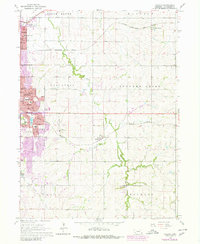
1964 Map of Walton
USGS Topo · Published 1980About this map
The expanding eastern limits of Lincoln meet the rural drainages of Stevens Creek in this mid-century portrait of Lancaster County. The map documents the urban transition of neighborhoods like Bethany and Havelock, where grid-based residential growth pushes against industrial landmarks such as the Grain Elevators and specialized facilities like the VA Hospital. Significant infrastructure including the Chicago Rock Island and Pacific and Missouri Pacific railroads bisect the landscape, defining the development corridors of outlying communities like Walton and Prairie Home.
Find a feature on this map
45 named features on this map. Tap any name to fly to it.
Don’t see what you’re looking for? This feature index may not catch every label — zoom into the map to look around manually.
Map Details
Editions of this 1964 Walton Map
3 editions found
Other maps of this area

1897 · Lincoln
USGS Topo · 1:125,000

1903 · Weeping Water
USGS Topo · 1:125,000

1929 · Weeping Water
USGS Topo · 1:125,000

1955 · Lincoln
USGS Topo · 1:250,000

1957 · Lincoln
USGS Topo · 1:250,000

1958 · Lincoln
USGS Topo · 1:250,000

1964 · Waverly
USGS Topo · 1:24,000

1964 · Roca
USGS Topo · 1:24,000

1964 · Davey
USGS Topo · 1:24,000

1964 · Walton
USGS Topo · 1:24,000