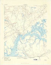
1943 Map of Wando
USGS Topo · Published 1943About this map
The Wando River dominates this coastal landscape during the early 1940s, serving as a critical boundary between Berkeley and Charleston counties. Along its banks, small landings like Lachicotte Landing and Martins Point Landing suggest a river-dependent economy and transport network. Inland, the presence of the Lumber Railroad slicing through the timbered tracts north of the river highlights the area's industrial reliance on forestry and shipping.
Find a feature on this map
27 named features on this map. Tap any name to fly to it.
Don’t see what you’re looking for? This feature index may not catch every label — zoom into the map to look around manually.
Map Details
Editions of this 1943 Wando Map
3 editions found

Other maps of this area

1919 · Capers Island
USGS Topo · 1:21,120

1919 · Wando
USGS Topo · 1:21,120

1919 · Cordesville
USGS Topo · 1:48,000

1919 · Melgrove
USGS Topo · 1:21,120

1919 · Charleston
USGS Topo · 1:21,120

1919 · Fort Moultrie
USGS Topo · 1:21,120

1919 · Sewee Bay
USGS Topo · 1:21,120

1940 · Melgrove
USGS Topo · 1:24,000

1943 · Capers Island
USGS Topo · 1:24,000

1943 · Fort Moultrie
USGS Topo · 1:24,000