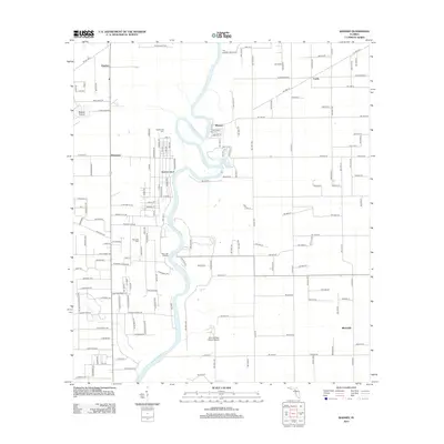
2012 Map of Wannee
USGS Topo · Published 2012About this map
The Suwannee River carves a winding path through this portion of Gilchrist County, defining a landscape shaped by its proximity to the water. The river corridor is punctuated by numerous natural springs, including Hart Springs, Lumber Camp Springs, and Sun Springs, which have long served as local landmarks. The settlement pattern here is dispersed, with small communities like Wannee, Blitchville, and Dixietown connected by a network of rural roads. Genealogists may find value in the locations of Fayetteville Cem and McCrabb Cem, while the inclusion of McCrabb Landing and Log Landing points to the historical importance of river-based transport. The southern reach of the map features the Otter Springs Resort Airport near Otter Springs, illustrating the intersection of natural recreation and local infrastructure in the early 21st century.
Find a feature on this map
166 named features on this map. Tap any name to fly to it.
Don’t see what you’re looking for? This feature index may not catch every label — zoom into the map to look around manually.
Map Details
Editions of this 2012 Wannee Map
This is the sole edition of this map. No revisions or reprints were ever made.
Other maps of this area

1954 · Eugene
USGS Topo · 1:24,000

1954 · Cross City East
USGS Topo · 1:24,000

1954 · Mallory Swamp SE
USGS Topo · 1:24,000

1954 · Gainesville
USGS Topo · 1:250,000

1956 · Mallory Swamp SE
USGS Topo · 1:25,000

1958 · Gainesville
USGS Topo · 1:250,000

1959 · Gainesville
USGS Topo · 1:250,000

1968 · Fourmile Lake
USGS Topo · 1:24,000

1968 · Hatchbend
USGS Topo · 1:24,000

1968 · Trenton
USGS Topo · 1:24,000