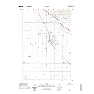
2020 Map of Wapato
USGS Topo · Published 2020About this map
The Yakima Valley floor is defined here by an intricate irrigation system, where the Sunnyside Canal and Union Gap Canal parallel the meandering course of the Yakima River. This 2020 layout shows the dense grid of the city of Wapato and the nearby settlement of Donald, illustrating the region's agricultural dependency on water management. Numerous drains and laterals, such as Drain 2 and Lateral 3, crisscross the landscape to support the local orchards and fields. To the northeast, the terrain rises sharply into the Rattlesnake Hills, providing a stark contrast to the flat valley floor. Smaller locales like Ashue, Venner, and Yethonat appear as key points along the secondary road network, including family-named routes like Kays Rd and Campbell Rd.
Find a feature on this map
87 named features on this map. Tap any name to fly to it.
Don’t see what you’re looking for? This feature index may not catch every label — zoom into the map to look around manually.
Map Details
Editions of this 2020 Wapato Map
This is the sole edition of this map. No revisions or reprints were ever made.
Other maps of this area

1899 · Ellensburg
USGS Topo · 1:125,000

1901 · Ellensburg
USGS Topo · 1:125,000

1910 · Zillah
USGS Topo · 1:125,000

1936 · Yakima East
USGS Topo · 1:48,000

1937 · White Swan
USGS Topo · 1:125,000

1941 · Yakima East
USGS Topo · 1:62,500

1950 · Yakima
USGS Topo · 1:250,000

1953 · Elephant Mountain
USGS Topo · 1:24,000

1953 · Yakima East
USGS Topo · 1:24,000
1953 · Yakima East
USGS Topo · 1:62,500