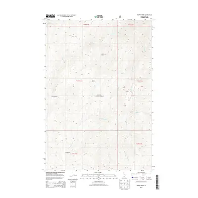
2013 Map of Wapiti Creek
USGS Topo · Published 2013About this map
McCalla Ridge and Chamberlain Basin dominate the high-elevation landscape of this 2013 Idaho County survey. Located within the Payette National Forest, the terrain is defined by its series of distinct high-country openings including Wapiti Meadows, Moose Meadows, and Club Meadows. These clearings are connected by a network of drainage systems, most notably Wapiti Creek and the multiple forks of Whimstick Creek. Human presence in this isolated area is represented by two specific landmarks: McCoy Cabin in the northern reach and Root Ranch further south. The map provides a precise look at the township and range divisions, illustrating how these administrative boundaries overlay the natural topography of the Big Creek and Salmon River backcountry.
Find a feature on this map
23 named features on this map. Tap any name to fly to it.
Don’t see what you’re looking for? This feature index may not catch every label — zoom into the map to look around manually.
Map Details
Editions of this 2013 Wapiti Creek Map
This is the sole edition of this map. No revisions or reprints were ever made.
Other maps of this area

1956 · Elk City
USGS Topo · 1:250,000

1960 · Elk City
USGS Topo · 1:250,000

1962 · Vinegar Hill
USGS Topo · 1:24,000

1973 · Acorn Butte
USGS Topo · 1:24,000

1973 · Bismark Mtn
USGS Topo · 1:24,000

1974 · Meadow Of Doubt
USGS Topo · 1:24,000

1978 · Arctic Point
USGS Topo · 1:24,000

1978 · Wapiti Creek
USGS Topo · 1:24,000
1978 · Lodgepole Creek
USGS Topo · 1:24,000

1978 · Devils Teeth Rapids
USGS Topo · 1:24,000