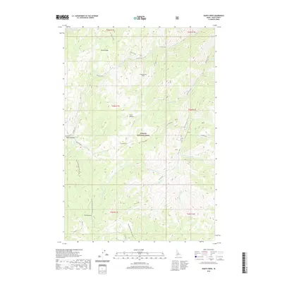
2020 Map of Wapiti Creek
USGS Topo · Published 2020About this map
Payette National Forest dominates this Idaho County landscape, showcasing a complex network of high-elevation meadows and drainages. The area is defined by its seasonal wetlands, including Wapiti Meadows, Moose Meadows, and Cold Meadows, which likely served as vital landmarks for early forest travelers. Topographically, the map centers on the transition from the McCalla Ridge down into the Chamberlain Basin, a remote region where water sources like Whimstick Creek and Wapiti Cr converge. The human footprint is sparse but telling, consisting primarily of legacy routes such as the McCoy Cutoff and the Frog Spring Ridge/Club Meadows trail, which trace the natural contours of the ridges and valley floors. This 2020 survey records the specific hydrological patterns of the Salmon River backcountry, detailing the myriad forks of Silver Creek and Club Cr before they depart the quadrangle.
Find a feature on this map
30 named features on this map. Tap any name to fly to it.
Don’t see what you’re looking for? This feature index may not catch every label — zoom into the map to look around manually.
Map Details
Editions of this 2020 Wapiti Creek Map
This is the sole edition of this map. No revisions or reprints were ever made.
Other maps of this area

1956 · Elk City
USGS Topo · 1:250,000

1960 · Elk City
USGS Topo · 1:250,000

1962 · Vinegar Hill
USGS Topo · 1:24,000

1973 · Acorn Butte
USGS Topo · 1:24,000

1973 · Bismark Mtn
USGS Topo · 1:24,000

1974 · Meadow Of Doubt
USGS Topo · 1:24,000

1978 · Arctic Point
USGS Topo · 1:24,000

1978 · Wapiti Creek
USGS Topo · 1:24,000
1978 · Lodgepole Creek
USGS Topo · 1:24,000

1978 · Devils Teeth Rapids
USGS Topo · 1:24,000