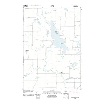
2010 Map of Wapogasset Lake
USGS Topo · Published 2010About this map
Wapogasset Lake and Bear Trap Lake dominate this Polk County landscape, serving as the central geographic features for the surrounding communities of Wanderoos, Deronda, and Little Falls. The shoreline is punctuated by several social and recreational landmarks, including Camp Icaghowan on Wallace Island and the Lutheran Bible Camp at Hickory Point. The hydrological network is well-defined by the Apple River flowing through the southern portion, where the Black Brook WP 66 Dam controls the local water levels. For those researching family history, the presence of the Travelers Rest Cemetery and Lincoln Cemetery provides specific points of interest in the northeast corner. The transition from these concentrated water bodies to the structured grid of agricultural roads like 110th Ave and Wanderoos Rd illustrates the late 20th-century rural layout of this Wisconsin lake region.
Find a feature on this map
60 named features on this map. Tap any name to fly to it.
Don’t see what you’re looking for? This feature index may not catch every label — zoom into the map to look around manually.
Map Details
Editions of this 2010 Wapogasset Lake Map
This is the sole edition of this map. No revisions or reprints were ever made.
Other maps of this area

1900 · St Croix Dalles
USGS Topo · 1:62,500

1901 · St Croix Dalles
USGS Topo · 1:62,500

1948 · New Richmond
USGS Topo · 1:62,500

1949 · New Richmond
USGS Topo · 1:62,500

1950 · Deer Park
USGS Topo · 1:62,500

1950 · Balsam Lake
USGS Topo · 1:62,500

1953 · Stillwater
USGS Topo · 1:250,000

1955 · St. Croix Dalles
USGS Topo · 1:62,500

1955 · Stillwater
USGS Topo · 1:250,000

1958 · Stillwater
USGS Topo · 1:250,000