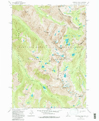
1972 Map of Warbonnet Peak
USGS Topo · Published 1986About this map
Warbonnet Peak and the surrounding high-elevation basins define this 1970s survey of the central Sawtooth Range. The landscape is dominated by the Sawtooth Wilderness, where numerous alpine water bodies like Baron Lake, Stephens Lakes, and Little Warbonnet Lake occupy glacial cirques. The drainage patterns are clearly delineated, showing the headwaters of the South Fork Payette River and its tributaries such as Goat Creek and Fall Creek.
Find a feature on this map
51 named features on this map. Tap any name to fly to it.
Don’t see what you’re looking for? This feature index may not catch every label — zoom into the map to look around manually.
Map Details
Editions of this 1972 Warbonnet Peak Map
3 editions found
Other maps of this area

1891 · Bear Valley
USGS Topo · 1:125,000

1893 · Bear Valley
USGS Topo · 1:125,000

1894 · Rocky Bar
USGS Topo · 1:125,000

1900 · Sawtooth
USGS Topo · 1:125,000

1919 · Custer
USGS Topo · 1:125,000

1922 · Custer
USGS Topo · 1:125,000

1955 · Hailey
USGS Topo · 1:250,000

1957 · Challis
USGS Topo · 1:250,000

1959 · Hailey
USGS Topo · 1:250,000

1960 · Challis
USGS Topo · 1:250,000