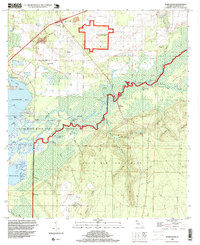
1994 Map of Ward Basin
USGS Topo · Published 1999About this map
Blackwater Bay and the winding course of the Yellow River dominate this coastal Florida landscape, where water and military history intersect. The northern reach is defined by the U.S. Naval Reservation Santa Rosa Field and the Interchange 10 corridor, while the southern half is largely consumed by the sprawling Eglin Air Force Base. Between these zones, the Yellow River Marsh State Aquatic Preserve protects a complex network of wetlands and bayous including Rattlesnake Bayou and Skim Lake. Local history is anchored by family and community landmarks such as Welcome Cem, Hickory Hammock Cem, and the Old Lane Place. Along the river, historical access points like Faulks Ferry Landing and Broxson Landing point to the area's long-standing reliance on the waterway for transport and industry.
Find a feature on this map
54 named features on this map. Tap any name to fly to it.
Don’t see what you’re looking for? This feature index may not catch every label — zoom into the map to look around manually.
Map Details
Editions of this 1994 Ward Basin Map
This is the sole edition of this map. No revisions or reprints were ever made.
Other maps of this area

1920 · Milton
USGS Topo · 1:62,500

1921 · Holley
USGS Topo · 1:62,500

1921 · Pensacola
USGS Topo · 1:62,500

1934 · Harold
USGS Topo · 1:62,500

1936 · Holley
USGS Topo · 1:48,000

1937 · Harold
USGS Topo · 1:62,500

1938 · Holley
USGS Topo · 1:62,500

1938 · Harold
USGS Topo · 1:62,500

1941 · Pensacola
USGS Topo · 1:62,500

1941 · Milton
USGS Topo · 1:62,500