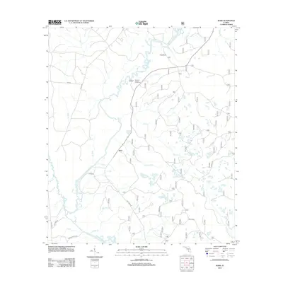
2012 Map of Ward
USGS Topo · Published 2012About this map
Ochlockonee River defines the western landscape of this Leon County region, where the river's winding course creates a network of swampy lowlands and named tributaries like Blue Cr and Reedy Br. The settlement pattern centers on small communities and river-access points such as Ward and Rock Bluff, reflecting a landscape deeply tied to the water. In the northern reaches, Stoutamire Landing and its associated Stoutamire Landing Campground mark a primary recreational area near Round Pond and Long Pond. Away from the main river corridor, the map details an extensive network of Forest Service roads, including Forest Rd 316 and Forest Rd 315, which navigate the pine-dominated terrain. To the south, the headwaters of the W Br Sopchoppy River and features like Rhodes Springs highlight the area's complex hydrology and its importance for local drainage into the Gulf coastal plain.
Find a feature on this map
36 named features on this map. Tap any name to fly to it.
Don’t see what you’re looking for? This feature index may not catch every label — zoom into the map to look around manually.
Map Details
Editions of this 2012 Ward Map
This is the sole edition of this map. No revisions or reprints were ever made.
Other maps of this area

1943 · Lake Talquin
USGS Topo · 1:62,500

1944 · Queens Bay
USGS Topo · 1:24,000

1945 · Smith Creek
USGS Topo · 1:31,680

1945 · Bradwell Bay
USGS Topo · 1:31,680

1945 · Hosford
USGS Topo · 1:31,680

1945 · Telogia
USGS Topo · 1:24,000

1946 · Queens Bay
USGS Topo · 1:31,680

1946 · Telogia
USGS Topo · 1:31,680

1954 · Tallahassee
USGS Topo · 1:250,000

1959 · Tallahassee
USGS Topo · 1:250,000