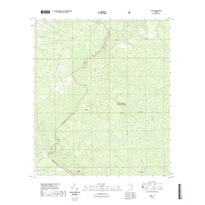
2021 Map of Ward
USGS Topo · Published 2021About this map
The settlement of Ward serves as a central point in this landscape where Leon, Liberty, and Wakulla counties converge within the Apalachicola National Forest. The geography is defined by the winding course of the Ochlockonee River, which forms a significant natural boundary and is paralleled by the Lower Ochlockonee River State Trail. This area is a complex network of wetlands and drainage systems, featuring numerous creeks like Yellow Jacket Creek and High Hill Creek, alongside distinct water bodies such as Round Pond and Long Pond. The presence of Rhodes Springs and the topographic rise at Rock Bluff highlights the varied hydrography of the Florida panhandle. A network of forest roads and local routes, including Smith Creek Road and Chason Road, provides access through the dense woodland and across the West Branch Sopchoppy River.
Find a feature on this map
52 named features on this map. Tap any name to fly to it.
Don’t see what you’re looking for? This feature index may not catch every label — zoom into the map to look around manually.
Map Details
Editions of this 2021 Ward Map
This is the sole edition of this map. No revisions or reprints were ever made.
Other maps of this area

1943 · Lake Talquin
USGS Topo · 1:62,500

1944 · Queens Bay
USGS Topo · 1:24,000

1945 · Smith Creek
USGS Topo · 1:31,680

1945 · Bradwell Bay
USGS Topo · 1:31,680

1945 · Hosford
USGS Topo · 1:31,680

1945 · Telogia
USGS Topo · 1:24,000

1946 · Queens Bay
USGS Topo · 1:31,680

1946 · Telogia
USGS Topo · 1:31,680

1954 · Tallahassee
USGS Topo · 1:250,000

1959 · Tallahassee
USGS Topo · 1:250,000