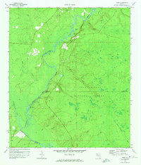
1972 Map of Ward
USGS Topo · Published 1974About this map
The Ochlockonee River winds through the heart of this landscape, forming a complex natural boundary between Liberty, Leon, and Wakulla counties. Within the Apalachicola National Forest, the terrain is defined by a dense network of water bodies, including Round Pond, Long Pond, and the Big Eddy. For genealogists, the map identifies small community centers such as Ward and the riverside Stoutamire Landing. Cultural landmarks are centered around rural congregations, specifically Blue Creek Ch (Cem) near the Blue Creek headwaters and Good Hope Ch (Cem) further south. The geography is characterized by distinct elevations like High Hill and the riverine features of Rock Bluff and Bluff, while numerous drainages like Sweetwater Creek and the West Branch Sopchoppy River feed into the regional basin.
Find a feature on this map
33 named features on this map. Tap any name to fly to it.
Don’t see what you’re looking for? This feature index may not catch every label — zoom into the map to look around manually.
Map Details
Editions of this 1972 Ward Map
This is the sole edition of this map. No revisions or reprints were ever made.
Other maps of this area

1943 · Lake Talquin
USGS Topo · 1:62,500

1944 · Queens Bay
USGS Topo · 1:24,000

1945 · Smith Creek
USGS Topo · 1:31,680

1945 · Bradwell Bay
USGS Topo · 1:31,680

1945 · Hosford
USGS Topo · 1:31,680

1945 · Telogia
USGS Topo · 1:24,000

1946 · Queens Bay
USGS Topo · 1:31,680

1946 · Telogia
USGS Topo · 1:31,680

1954 · Tallahassee
USGS Topo · 1:250,000

1959 · Tallahassee
USGS Topo · 1:250,000